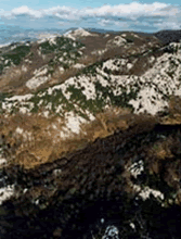
Velebit is the largest mountain in Croatia and is a part of a bigger mountain chain of Dinarides stretching form the Alps, across Croatia, Bosnia and Herzegovina and Montenegro to Albania. The area of Velebit Mountain comprises 2.359 square kilometres. The mountain stretches in the form of slightly bended arch along the Adriatic coast in the northwest-southeast direction, between the Vratnik pass and the river Zrmanja valley.

The mountain is approximately 145 km long, its width varying form 30 km at the northern parts to 10 km at its southern parts. On its western parts, Velebit Mountain chain raises sharply from the sea, dominating over the landscape. Towards the east, its slopes descend more mildly into the plateau of Lika, situated between 425 and 600 meters above the sea level. The highest peak of the Velebit Mountain is Vaganski vrh (1757 m a. s. l.) in Paklenica National Park. Geographically, Velebit can be divided roughly into four parts. Mountain passes Vratnik, Veliki Alan, Baške Oštarije and Prezid divide northern, middle and southern parts. In southeastern parts, mountain massif stretches towards the inland along the river Zrmanja canyon.
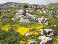
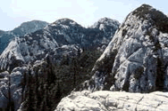
Velebit is typical karst mountain, composed largely of carbonate rocks. All types of karst phenomena as well as their transitional stages can be observed on Velebit Mountain, both on the surface and in the underground. Among surface karst phenomena are: Karren, sinkholes (“ponikve”), karst planes, uvalas, dolina, bogazes, denuded karst peaks (“kukovi”), columns, ice-pits, canyons, karst rivers with travertine (Zrmanja, Krupa), karst springs, lakes and abysses. Subterranean karst phenomena are equally diverse and interesting, deep pits, caves, underground lakes and submarine springs (“vrulje”) being among the most interesting. The mountain itself is scarce with water, karst springs and surface watercourses are rare, especially in the northern and middle parts. Despite of that, inside the Velebit massif there are huge freshwater reserves. Karst rivers in the continental side of Velebit (first of all Lika and Gacka), disappear underground just in front of the Velebit massif, finding their way through it towards the Adriatic Sea. There they emerge again as the costal springs and special form of submarine springs (“vrulje”).

The water is by far one of the most important factors that, by dissolving the carbonate rocks, shaped the Velebit karst, as it is today, both on the surface and in the underground. In Velebit area about 90 different habitat types, according to the CORINE classification, can be distinguished, some 20 of them in Paklenica National park alone. That is about 70% of all habitat types found in Croatia. The most conspicuous feature of Velebit Mountain is the presence of the “two different faces” – one on the Adriatic coastal slopes and one on the continental slopes. The differences between them can be observed in the variety of features – vegetation, habitats and species, as well as in the habits of people living there. From the foothill to the mountaintops, vertical zoning of the vegetation belts can be clearly seen.
Velebit has very high biological diversity, due to very diverse habitats but also to the fact that some part of the mountain acted as refugia for numerous species during glaciations in the past. Some 2500 plant species have been described, about hundred being endemic. Special, isolated habitats with extreme conditions, such as mountaintops, rock crevices, subterranean habitats and submarine springs favoured the development of specific flora and fauna. Among them, endemic genus of leech (Croatobranchus mestrovi) can be pointed out due to its specific ecology and the level of adaptations to extreme life conditions – so far, it has been found exclusively in the very deep pits in Sjeverni Velebit National Park. All the above contributed to the development of diverse landscapes on the Velebit Mountain that create an extraordinary appealing mosaic. Because of its multiple natural values, Velebit Mountain has been attracting the attention of both domestic and international scientists and experts, for a long time. First official attempts to protect the area date back to the late 20-ies of the last century. At that time, forests of Štirovaca and Paklenica were declared as national parks. According to the law, this status should have been reaffirmed on a yearly basis. Since that had not been the case, both areas had lost their status of protection.
After the Second World War, in 1949, Paklenica National Park was established in the southern part of Velebit, around two impressive canyons (of Velika and Mala Paklenica). International recognition was expressed in 1978, when the whole mountain became a Biosphere Reserve, within the UNESCO’s Man and Biosphere Program (MAB). After that, mountain was declared a Nature Park, its boundaries more or less corresponding to those of the Biosphere Reserve. To summarize, both Paklenica and Sjeverni Velebit National Park are situated within the borders of Velebit Nature Park that comprises almost the whole Velebit Mountain, and is a Biosphere Reserve in the same time. There is also a series of other smaller protected areas of different status, inside the three parks.
The most important is Hajducki and Rožanski kukovi Strict Reserve, within Sjeverni Velebit National Park. It is globally significant as one of the world’s most famous localities of very deep, vertical speleological objects – pits. More than 200 entrances have been discovered so far, at the area of only 12 square kilometres. The deepest and most famous is Luka’s pit (-1392 m), being 11th in the world, its bottom (water-filled siphon) being situated at only 80 m above the sea level. Some other protected properties are present: special reserve of forest vegetation (Klepina duliba), special botanical reserves (Visibaba and Zavižan-Balinovac-Velika kosa), geomorphologic nature monuments (Cerovacke caves and Modric cave), protected landscape (Zavratnica), paleontological nature monument (Velnicka glavica) and several archaeological and paleontological localities. Through the history, traditional economic activities on the Velebit Mountain have been cattle breeding in the first place, and forestry.
Due to the scarcity of arable land, agriculture had never played a very important role. Along the coast, fishery was important activity. There are no major industrial plants in the area, not even today. Over the past decades, tourism has developed and became major source of income in the costal area. Besides its natural values, the cultural heritage of Velebit Mountain is equally rich and precious. Evidence of human presence can be followed from prehistoric times until present days, especially in the lower parts of the mountain, with milder climate. There are valuable archaeological sites from Stone and Iron Age (Jatara and Vaganacka cave), as well as finding places of the Roman glass – Argyruntum. Because of the harsh climate, in the top parts of Velebit there had never been permanent settlements. However, people from the mountain villages on the coastal slopes, used to bring their cattle there for grazing in summer periods, as the snow line would be withdrawing.
In the mountain, they used to build the so-called summer lodges. They are plentiful on Velebit Mountain, and the locality called Mirovo, situated in Sjeverni Velebit National Park is one of the biggest and most impressive complexes. uring short summer periods they would work the small patches of land they cleared off of rocks, bushes and trees. To build both their houses and the summer lodges, they used the most abundant material available – the stones. In some cases, the settlements are so well preserved so that they can be regarded as ethno-villages, like the hamlet Marasovici near the entrance to Paklenica National park. Velebit mountain passes were very important communication and trading routes between the coast and the inland.
The roads build for that purpose are the masterpieces of the building heritage and stone-carving skills. The part of this rich heritage are numerous wells and springs, water-mills, sacral objects, traditional trails and “mirila” – these are specially arranged stones along the Velebit traditional trails where people used to take some rest during the transport of their dead from the mountain towards its foothill. This is a specific cultural heritage in this area. Long-lasting influence of human presence was at most cases “sustainable”, and people lived in the harmony with the mountain nature, although such a living was sometimes very hard. Even more, by grazing their cattle, by building ponds and stonewalls, man had created favourable new habitats, thus contributing significantly to the present attractiveness of landscapes and biological diversity in the Velebit Mountain.

Although relatively preserved form the negative impact of human activities, Velebit Mountain has recently been exposed to the different sorts of developmental pressures, from the road constructions and uncontrolled building in the costal area, to the overuse of natural resources. Obviously, the influence of global factors, such as climate change and transboundary aerial pollution is unavoidable. The perspective of the Velebit Mountain is thus seen in the better and more efficient protection of all its resources. For the inclusion in the World Heritage List, the area within the present borders of Velebit Nature Park is proposed. Administratively, proposed item belongs to the territory of three Counties (Licko-Senjska, Zadarska and Šibensko-Kninska). The total size of the proposed area is approximately 2000 square kilometers.
